Last of the Westland Whigs

In the late 17th century, the 'Westland Whigs' were the radical descendants of earlier Covenanters who had defied the absolutist rule of Stuart kings in south west Scotland.

Thursday, September 27, 2012

Castle Douglas station plan 1894

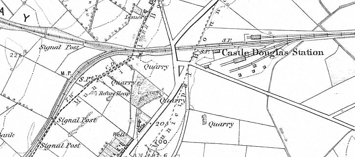
Castle Douglas Railway Station 1894
The above plan of Castle Douglas railway station is based on the 1894 25 inch to the mile maps, by printing and pasting two adjacent sheets. It can be compared with the six inch to the mile map below which shows the layout as it was in 1864, just after the branch to Kirkcudbright was opened. The Kirkcudbright branch diverges to the bottom left hand corner. Above it is the Portpatrick (and Stranraer) Railway which was opened in 1862.

Castle Douglas Railway Station 1864
In 1864, the Kirkcudbright branch joined the Portpatrick Railway some distance from the station. The junction was then changed so the lines diverged within the station. The dotted line of the town boundary shows the original route of the road from Dumfries into the town before it was diverted around the station.

This photograph shows the track formation.The line to Stranraer and Portpatrick enters from the left, the line from Kirkcudbright on the right.The path on the right gave access to Signal Box No. 2.

Castle Douglas station track formation
By 1959 the layout had been simplified, although the over-bridge was still double span. The next photograph shows a train taking the Kirkcudbright branch in 1959.

Castle Douglas station looking west 1959. Kirkcudbright train departing.
 Finally, between 1959 and 1965 when the line closed, the track layout was further simplified and one span of the over-bridge filled in.

Castle Douglas station looking east with bridge reduced to one span.

Monday, September 10, 2012

Galloway Picts Trusty's Hill September update

Rock cut well at Trusty's Hill May 2012. 

This is the latest update (10 September 2012) from the Galloway Picts / Trusty's Hill project


Some of the results we were able to divulge at the conference, for the first time, were the radiocarbon dates taken from eight separate pieces of charcoal and one single fragment of wood from a variety of contexts (or layers) from Trusty’s Hill. We now have a calibrated radiocarbon date of 536-646 AD from the occupation soil in Trench 4 that abutted the vitrified rampart along the east side of the summit of the fort, which is matched by a date of 533-643 AD from occupation soil in Trench 5 that abutted the rampart on the western side of the fort summit. Calibrated dates from a construction layer (of material swept up and laid across the rock-cut foundation trench) of the rampart include 529-623 AD from the east side and 513-378 BC from the west side.
 Another Iron Age date of 515-381 BC was recovered from the base of a structural post-hole within the rampart at the west side though a lens of material from the core of the rampart above this yielded a date of 536-646 AD. The earliest stratigraphic occupation deposit in the corner of Trench 4 provided a radiocarbon date of 411-543 AD, while the backfill soil from Charles Thomas’ excavation of Trench 4 yielded a date of 551-646 AD. Meanwhile a piece of wood taken from the base fill of the rock-cut basin at the opposite side of the entranceway to the Pictish carvings was radiocarbon dated to 661-773 AD.
In summary, the radiocarbon dating indicates initial occupation of Trusty’s Hill around 400 BC. We don’t think the vitrified rampart dates to this time however, as an early sixth-early seventh century date was also obtained from this layer and another early sixth – mid seventh century AD date was taken from the vitrified rampart itself. Rather, we think the Iron Age material found within the foundation trench of the vitrified rampart is residual, swept up from the interior of the site and laid out as a bed of material for the timber frame and stone core of the rampart.
 The Iron Age occupation of Trusty’s Hill appears to have been followed by a hiatus before the hill was re-occupied in the early fifth to early sixth century AD and fortified with a timber-laced rampart around its summit between the early sixth and mid seventh century AD. The rampart was probably destroyed around the end of this period in the early-mid seventh century AD. Interestingly, this broadly accords with Charles Thomas’ interpretation of two phases of occupation; that of an original Iron Age site re-occupied in the fifth/sixth century AD. 
However, the radiocarbon date taken from the base of the rock-cut well at the entranceway indicates that this feature was still open and presumably used in the later seventh – eighth centuries AD, after the fort had been destroyed, which suggests that it was of sufficient importance to merit continued use long after occupation of the hillfort had ended.